Mapping the American Revolution Symposium
Maps relating to the November 2022 Mount Vernon George Washington Symposium, Mapping the American Revolution
-

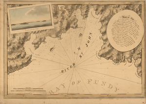
The coast of Nova Scotia, New England, New-York, Jersey, the Gulph and River of St. Lawrence
Norman B. Leventhal Map & Education Center Collection
-
-
-
-
-
-

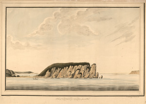
The north point of Grandmanan Island in the bay Fundy bearing e.n.e distant two leagues ; A view of Campo Bello at the entrance of Passamaquady Bay
Library of Congress Collection
-
-
-
-
-

Halifax Harbour ... Catch Harbour ... small vessels only
Norman B. Leventhal Map & Education Center Collection
-

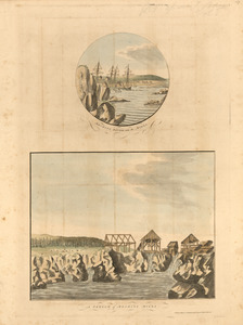
A view from the south eastward of Halifax Harbor
Norman B. Leventhal Map & Education Center Collection
-

View of Cape Egmont and winter Rock from the eastward
Norman B. Leventhal Map & Education Center Collection
-

A new map of Nova Scotia, and Cape Britain
Richard H. Brown Revolutionary War Map Collection at Mount Vernon
-
![A map of the most inhabited part of New England containing the provinces of Massachusets Bay and New Hampshire with the colonies of Connecticut and Rhode Island divided into counties and townships the w[h]ole composed from actual surveys and its situation adjusted by astronomical observations](https://bpldcassets.blob.core.windows.net/derivatives/images/commonwealth:6t053p316/image_thumbnail_300.jpg)
A map of the most inhabited part of New England containing the provinces of Massachusets Bay and New Hampshire with the colonies of Connecticut and Rhode Island divided into counties and townships the w[h]ole composed from actual surveys and its situation adjusted by astronomical observations
Norman B. Leventhal Map & Education Center Collection
-
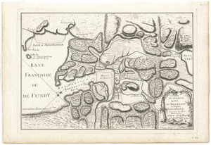
L'isthme de l'Acadie, Baye du Beaubassin, en Anglois Shegnekto, environs du Fort Beausejour
Richard H. Brown Revolutionary War Map Collection at Mount Vernon
-
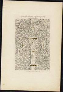
A plan of the disposition of the advanced party consisting of 400 men
Richard H. Brown Revolutionary War Map Collection at Mount Vernon
-
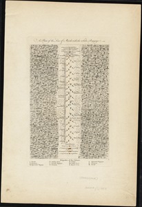
A plan of the line of march of the detachment from the little Meadows
Richard H. Brown Revolutionary War Map Collection at Mount Vernon
-
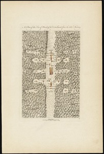
A plan of the encampment of the detachment from the little Meadows
Richard H. Brown Revolutionary War Map Collection at Mount Vernon
-
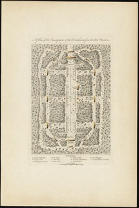
A plan of the line of march with the whole baggage
Richard H. Brown Revolutionary War Map Collection at Mount Vernon
-

A map of the country between Will's Creek & Monongahela River shewing the rout and encampments of the English army in 1755
Richard H. Brown Revolutionary War Map Collection at Mount Vernon
-

A plan of the field of battle and disposition of the troops, as they were on the march at the time of the attack on the 9th of July, 1755
Richard H. Brown Revolutionary War Map Collection at Mount Vernon
-
To the rt. honble. the Earl of Halifax, first lord commissioner of trade & plantations, &c &c this chart of Chibucto Harbour, on the coast of Accadia, or Nova Scotia, with the plan of the town of Halifax
Richard H. Brown Revolutionary War Map Collection at Mount Vernon
-

A map of the inhabited part of Canada from the French surveys
Richard H. Brown Revolutionary War Map Collection at Mount Vernon
-
-

The theatre of war in North America, with the roads and a table of the distances
Richard H. Brown Revolutionary War Map Collection at Mount Vernon
-

A PLAN of the TOWN of St ANDREWS Situated at the Head of Passamaquoddy Bay-laid out for the Accomodation of Loyal Emigrants & disbanded Corps
British Library Collection
-

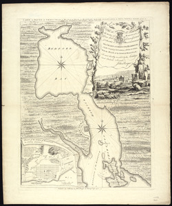
A map of Pensilvania, New-Jersey, New-York, and the three Delaware counties
Massachusetts Historical Society Map Collection
-

To the Honourable Thomas Penn and Richard Penn, Esqrs., true & absolute proprietaries & Governours of the Province of Pennsylvania & counties of New-Castle, Kent & Sussex on Delaware this map of the improved part of the Province of Pennsylvania
Norman B. Leventhal Map & Education Center Collection
-
-
-
-
-
-
-
-
-
-
-
-
-
-
-
-

![Atlantic Neptune [front matter]](https://bpldcassets.blob.core.windows.net/derivatives/images/commonwealth:3f462w98b/image_thumbnail_300.jpg)